
By GREGORY ZELLER //
As coastal storms increase in frequency and ferocity, the U.S. Army Corps of Engineers has engaged a massive risk-management project designed to protect Long Island’s most vulnerable low-lying areas.
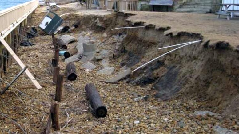
![]() The multifaceted Fire Island to Montauk Point project will attempt to reduce flood risks along 83 miles of Suffolk County coastline. On the drawing board are elevations and other “retrofits” for roughly 4,400 structures in frequently flooded areas and an intelligence-gathering Breach Response Plan – first step in a developing action plan for waterfront areas known to suffer the worst of severe storms.
The multifaceted Fire Island to Montauk Point project will attempt to reduce flood risks along 83 miles of Suffolk County coastline. On the drawing board are elevations and other “retrofits” for roughly 4,400 structures in frequently flooded areas and an intelligence-gathering Breach Response Plan – first step in a developing action plan for waterfront areas known to suffer the worst of severe storms.
And those are just for starters. All told, the FIMP project will throw $1.7 billion – fully funded by the Army Corps of Engineers and New York State – toward Long Island coastal protection and “a variety of features to reduce coastal flood risks,” according to Gov. Kathy Hochul’s office.
Basil Seggos: Ramping up resiliency.
“This project will safeguard Suffolk County communities from severe storms and sea-level rise,” the governor said in a statement, adding the work is “essential for preserving Long Island’s treasured natural resources for future generations.”
In addition to the structural retrofits and the four-part Breach Response Plan, the FIMP project is slated to include the removal of existing groins and jetties at Fire Island’s Ocean Beach; the artificial widening of beaches at Montauk Beach; the construction of new coastal features designed to replicate and enhance shorebird habitats; and new dredging work at the region’s federal navigation channels.
Also planned are beach and dune fills at various vulnerable spots, with “renourishment” scheduled for every four years over the next three decades.
A combination of immediate infrastructure improvements and long-term maintenance would seem to be the ticket for the Suffolk County South Shore. According to Hochul’s office, New York State has been wobbled by 84 tropical or subtropical cyclones over the last 400 years, with the worst – except 2012’s Superstorm Sandy, which eroded half of existing beach sediment in some spots – occurring in the 1930s, before storms were named.
The FIMP project will kick off with the relocation of 1.5 million cubic yards of sand – moving from Fire Island Inlet to Gilgo Beach and Robert Moses State Park Beach, where it will strategically strengthen coastal resiliency. Engineers will also install “coastal process features” to improve piping plover habitats in Robert Moses State Park.
![]() As the FIMP project’s “non-federal sponsor,” the New York State Department of Environmental Conservation completed state-level engineering reviews and permitting processes. The DEC also worked with federal, state and local partners to plan, design and implement the project, which is essential to “meet the challenges of our changing climate” and “reduce flood risks for Long Islanders,” according to DEC Commissioner Basil Seggos.
As the FIMP project’s “non-federal sponsor,” the New York State Department of Environmental Conservation completed state-level engineering reviews and permitting processes. The DEC also worked with federal, state and local partners to plan, design and implement the project, which is essential to “meet the challenges of our changing climate” and “reduce flood risks for Long Islanders,” according to DEC Commissioner Basil Seggos.
“Year after year, our changing climate is driving an uptick in flooding and severe storms,” Seggos said in a statement. “To protect our communities and our natural resources, we must work together to increase resiliency, reduce climate-altering greenhouse gas emissions, and ramp up renewable-energy sources.”